Cornell Tech Urban Tech Hub On Roosevelt Island Hosting NYC Open Data Session On Bike Safety Friday March 11 Followed By Drinks At Granny Annie's – Any Solutions For Unsafe Roosevelt Island Bridge Bike Lane?
Register for a great Open Data Week event at
@cornell_tech
! Hear and discuss how open data can help us better understand and improve
bike lanes and city streets. Attend in-person or virtually, in conjunction
with
@BetaNYC and
@NYCAnalyticshttps://t.co/3xaDHEAE6N
Did you know New York City has the oldest bike lane in America, and one of the largest bike networks, plus bike share programs in North America?
The Covid-19 pandemic introduced hundreds of thousands of New Yorkers to this bicycle infrastructure for the first time. This session highlights student research from Cornell Tech that explores the intersection of open data and how the City can enhance multiple generations of infrastructure improvements with a focus on safety.
Join us to learn how to use open data to understand the past and present, while building a safer future for all in New York City. This hybrid session will be introduced by the Citys Chief Analytics Officer, Martha Norrick, and is organized by the Cornell Tech Urban Tech Hub….
… All in-person attendees are invited to join us for a closing reception at Granny Annies Bar & Kitchen, 425 Main St, New York, NY 10044 (on Roosevelt Island). We look forward to seeing you!
Julie Menin is the NYC Council Member representing Roosevelt Island.
I can attest to that issue as well as if you try riding over on certain
bikes aka a road bike the grates will pop the tires. Multiple tires blown
just by riding over.
A Roosevelt Island resident and bike rider reported Saturday February 26:
Ive been in touch with DOT regarding the flex posts coming down and blocking the bike lane in great numbers. I tried reporting through both RIOC systems but that didnt work, so I went through 311/DOT. They responded by putting up these huge orange barriers that fall over into the bike lane (and everywhere else), further obstructing it (north lane):
And now the south lane looked like this on Thursday and Friday:
Ive reported at least 3x in the last several months. Seems the old flex posts are due for removal and replacement, stat.
When Im not caught completely unaware of the fact that the bike lane is blocked by debris of the system that was designed to protect me,
I take the bridge lane. This is my right as a cyclist in NYC, but inevitably, cars blow by me on the bridge as they cant be bothered to follow me across.
From my perspective, riding a pedal-assist cargo bike with 2 kids on the back for school runs, this is a hazardous situation we cant afford to ignore.
At the very least, we should have signs that alert drivers that cyclists have the right to take the bridge lane. And, RIOC should respond to tickets filed in some way – even if to say its DOTs responsibility and provide link to the form for DOT. If the condition cant be immediately corrected, signage warning cyclists the lane is blocked would be prudent.
On March 2, the Roosevelt Island bike rider added:
This mornings offering. Im not sure why all of these moveable safety
objects are placed where they can fall into and obstruct the bike lanes. Id
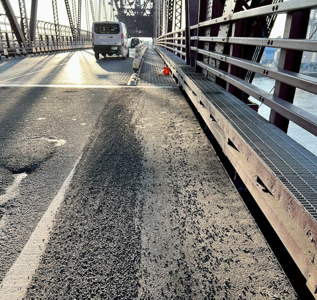
also note the presence of a large amount of gravel on the shoulder in run
ups to the bike lanes on both sides. This appeared after the first snowstorm
of the season and has remained since.
An update today from the Bike Rider:
The day of my last email to you, the graveldisappeared, which was great.
The high winds earlier this week blew a bunch of the moveable orange and white barriers back into the northbound lane. However, they seem to be doing better about getting things out of the bridge bike lanes,because that only lasted a day this time. There’s still some obstruction in the north lane, but it’s better than it being completely impassable.
Roosevelt Island could also use effective bike safety signage like these in Central Park